BC’s distinctive tuya volcanoes reveal glacial, palaeo-climate secrets
April 30, 2013
April 30, 2013
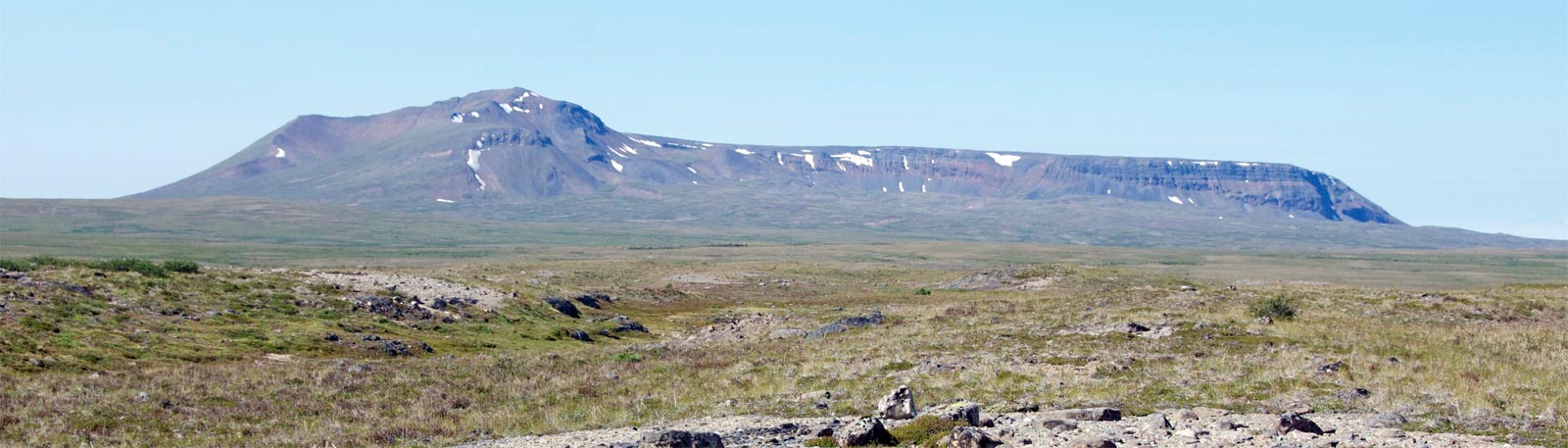
Deposits left by the eruption of a subglacial volcano, or tuya, 1.8 million years ago could hold the secret to more accurate palaeo-glacial and climate models, according to new research by UBC geoscientists.
The detailed field mapping and sampling of the partially eroded Kima' Kho tuya in northern British Columbia, Canada shows that the ancient regional ice sheet through which the volcano erupted was twice as thick as previously estimated.
Subglacial eruptions generate distinctive deposits indicating whether they were deposited below or above the waterline of the englacial lakes--much like the rings left on the inside of a bath tub. The transitions from subaqueous from subaerial deposits are called passage zones and define the high stands of englacial lakes. The depth and volume of water in these ephemeral lakes, in turn, gives researchers an accurate measure of the minimum palaeo-ice thicknesses at the time of eruption.
“At Kima'Kho, we were able to map a passage zone in pyroclastic deposits left by the earliest explosive phase of eruption, allowing for more accurate forensic recovery of paleo-lake levels through time and better estimates of paleo-ice thicknesses,” says UBC volcanologist James K Russell, lead author on the paper published this week in Nature Communications.
“Applying the same technique to other subglacial volcanos will provide new constraints on paleoclimate models that consider the extents and timing of planetary glaciations.”
While relatively rare globally, tuyas are common throughout Iceland, British Columbia, Oregon, and beneath the Antarctic ice-sheets. Kima'Kho tuya forms a high relief structure covering 28 square kilometres rising 1,946 metres above sea level on the Kawdy Plateau near Dease Lake. The plateau hosts six other tuyas.
“We hope our discovery encourages more researchers to seek out pyroclastic passage zones,” says Lucy Porritt, a Marie Curie Research Fellow at UBC and University of Bristol. “With more detailed mapping of glaciovolcanic sequences, and the recognition of the importance of these often abrupt changes in depositional environment, our understanding of glaciovolcanic eruptions and the hazards they pose can only be advanced.”

June 30, 2025
Researchers have identified buried copper ore by testing the DNA of microbes in the surface soil.These ‘biological fingerprints’ can reveal copper-containing ore buried tens of metres below the earth’s surface without having to drill, according to new research in Geology.“Copper is essential for… read more
June 17, 2025
Wildfires pollute waterways and could affect their ability to sequester carbon, new University of British Columbia research shows. Dr. Brian Hunt, professor in the Institute for the Oceans and Fisheries (IOF), and Emily Brown, IOF research scientist, discuss how wildfires affect our waters and… read more
December 2, 2024
UBC is bringing its expertise in critical minerals to the Rio Tinto Centre for Future Materials, a $150 (US) million research endeavour to fundamentally change how we produce, use and recycle the minerals needed for modern technologies and the clean energy transition. Dr. Steven… read more
We honour xwməθkwəy̓ əm (Musqueam) on whose ancestral, unceded territory UBC Vancouver is situated. UBC Science is committed to building meaningful relationships with Indigenous peoples so we can advance Reconciliation and ensure traditional ways of knowing enrich our teaching and research.
Learn more: Musqueam First Nation